

Active Transportation
Why should we plan for active travel?
Traveling by bike, bus, train, or on foot is a great way to be more physically active. When we use these forms of transportation to get to where we need to go, we are more likely to be happier and healthier.1-3 Urban and regional planners can support a healthy community by making it easy to get around by these modes, which we call active transportation.1 For example, planners can make sure that there are sidewalks for people to walk on. They can plan trails for bikers and walkers that connect residential areas to shopping areas. They can also make sure roads are designed so that cars don’t go too fast. That way, people feel safer walking and biking.4 Lastly, planners can ensure that there is efficient public transportation to take people where they need to go. By increasing the number of people who walk, bike, and use public transportation, communities can help fight obesity and other diseases.2,5
best practices for urban & Suburban Comprehensive Plans
Click the plus sign (+) to see more information about that best practice.
-- Include a goal or objective to reduce car dependency or vehicle miles traveled
-- Include a goal or objective to increase the number of citizens who walk, bike, and/or use public transit to get to work and other daily activities
+ Establish a “Complete Streets” policy
- Recommend that road construction and reconstruction incorporates the needs of all road users in a context-sensitive manner. Consider using design elements like traffic calming, pedestrian-friendly streetscapes, sidewalks, bike routes, and well-marked crosswalks and signage.
+ Include or refer to a bicycle/pedestrian plan
- Include targeted and detailed plans for improving bicycle/pedestrian access in specific locations throughout your jurisdiction.
+ Include traffic calming goals and strategies
- Traffic calming features include roundabouts, center islands and raised medians, street narrowing, raised intersections, short block lengths, speed bumps or humps, rumble strips, chicanes, and road diets, among others.
- Communities may need to work with their state or county department of transportation and/or metropolitan planning organization to plan, design, and fund traffic calming measures.
+ Include strategies that improve pedestrian mobility and safety
- Pedestrian safety and mobility measures include complete sidewalk systems, widened sidewalks, buffers between sidewalks and roadways (like street trees, terraces, or street parking), accessible pedestrian signals at intersections, and frequent and safe crosswalks, among others.
- Communities may need to work with their state or county department of transportation and/or metropolitan planning organization to plan, design, and fund pedestrian features.
-- Require developers to provide bicycle, pedestrian, and wheelchair access in new communities, including sidewalks, bicycle/pedestrian trails, bicycle lanes, bicycle racks, pedestrian crosswalks, and curb cuts
+ Include specific goals or objectives for the development or extension of off-road greenways and trails for biking and walking
- Specify targets for lane-miles, location of facilities, timeline, or budget.
+ Recommend reduced parking requirements for developments located near transit stops and/or with bicycle, pedestrian, and wheelchair access
- Recommended a policy regarding parking standards, such as reduced parking requirements, on-street parking, and/or shared parking in developments that meet active transportation criteria.
+ Recognize access to health care and mobility as issues of special concern to aging populations
- Cite local statistics and create specific policy goals related to the mobility of aging populations and their access to health care.
+ Recognize access to health care and mobility as issues of special concern to disadvantaged populations
- Cite local statistics and create specific policy goals related to the mobility of disadvantaged populations and their access to health care.
+ Support “Safe Routes to School” for children or other mechanisms that support children walking or riding bikes to schools, including locating schools closer to residential areas
- Create policy goals that include working with school districts, public safety, transportation, or education agencies.
- Refer to a current “Safe Routes to School” plan, or if one does not exist, recommend that it is developed.
+ Support the co-location of community services in school buildings
- Proactively establish a goal of working with relevant agencies and local school districts to co-locate community services in existing or new school buildings.
- Examples of services that could be located in school buildings are senior centers, public libraries, wellness centers, and public meeting spaces.

Bike lanes, sidewalks, and crosswalks ensure pedestrian and bicyclist safety and comfort. Photo credit: Complete Streets.

Curb extensions can help calm traffic by narrowing travel lanes and adding visual interest. Photo credit: Richard Drdul.
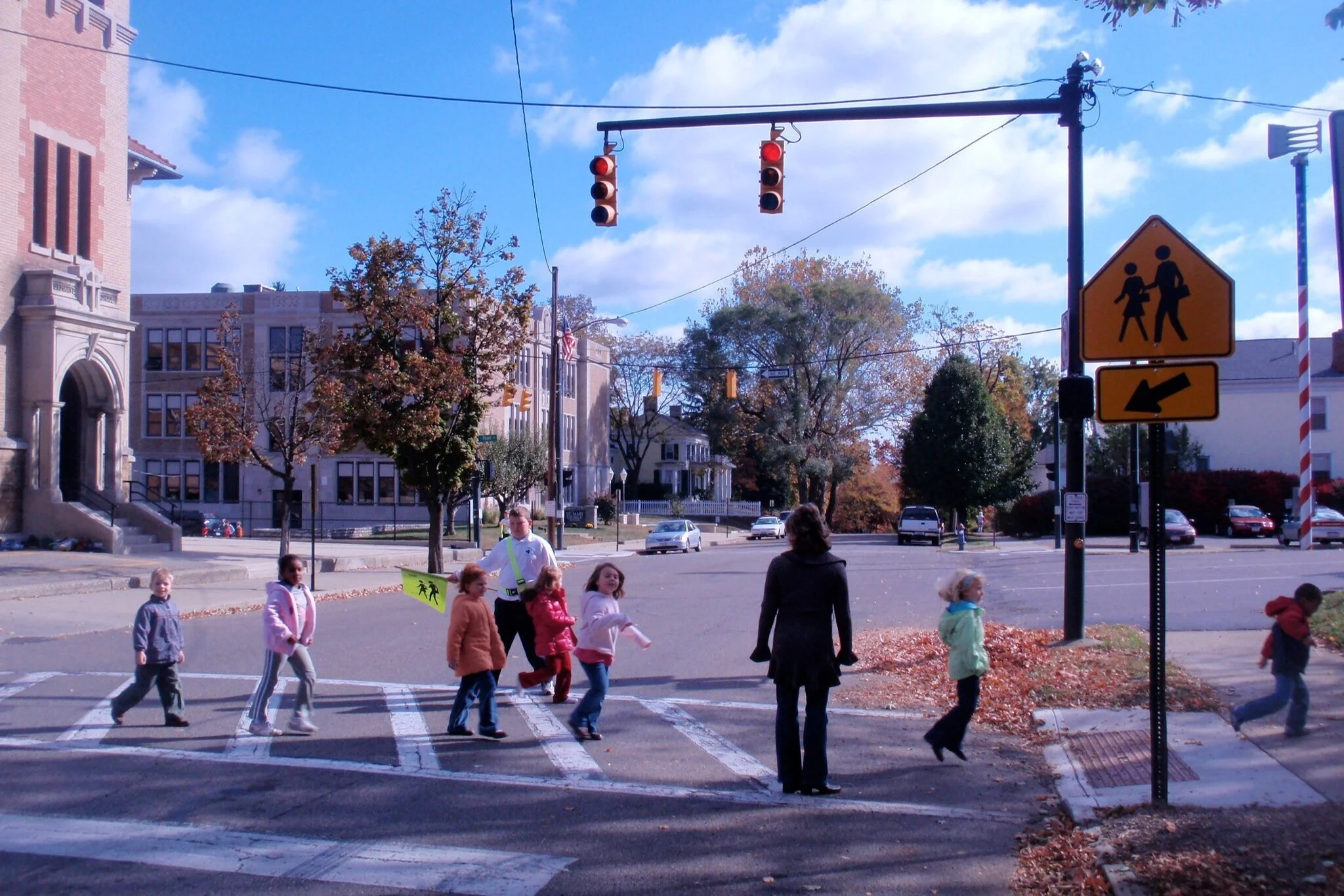
Crosswalks and other pedestrian infrastructure can make it safer for children to walk to and from school. Photo credit: Transportation for America.
Best Practices for Rural Comprehensive Plans
Click the plus sign (+) to see more information about that best practice.
-- Include a goal or objective to increase the number of citizens who walk, bike, or take public transit to get to work and other daily activities
+ Set goals and objectives to reduce pedestrian and bicycle traffic injuries
- Use crash data to identify areas of concern and set specific goals for decreasing injuries.
+ Include specific goals or objectives for the development or extension off-road greenways and trails for biking and walking.
- Trails should increase connectivity between residential areas and activity hubs and/or connect to regional trail systems.
- Refer to a standalone bicycle/pedestrian plan or outdoor recreation plan that contains specific goals for extending trails. If a bicycle/pedestrian plan does not exist, recommend that one is developed.
+ Establish a “Complete Streets” policy
- Recommend that road construction and reconstruction incorporates the needs of all road users in a context-sensitive manner.
- Note: Establishing a Complete Streets policy can help you retain some level of community control in the planning of state or county road projects.
+ Set a goal or objective to improve pedestrian and bicyclist mobility and comfort, especially between activity hubs and residential developments
- Identify key gaps in the pedestrian and bicycle networks and address these gaps through context-sensitive design solutions like:
- Widened, paved shoulders on country roads
- Paths that parallel country roads or provide more direct connections than country roads
- Increased sidewalk coverage
- Limited cul-de-sacs and dead-end roads, or bicyle/pedestrian connections between them and other roads
- Lower speed limits
- “Share the road” signs
- Bicycle/pedestrian wayfinding signage
+ Set a goal or objective to establish or extend public transit services, especially those for the elderly, disabled, or otherwise disadvantaged
- Identify specific strategies to achieve this goal/objective.
- While a fixed route service might not be possible in rural areas, other solutions exist. Examples include:
- Demand-response systems (like dial-a-ride)
- Flexible fixed-route systems
- Rideshare services or vanpools
- Public taxi
- Circulator systems
- Sharing facilities, equipment, and/or services with regional, metro, or county transit services
- Partnerships help make rural transit work. Potential partners include:
- Federal programs
- Metro areas and counties
- Regional planning commissions
- State departments of trnasportation
- Nonprofits
- Health and human service agencies
- Schools and universities
- Local businesses and employers
+ Support “Safe Routes to School” for children or other mechanisms that support children walking or riding bikes to schools, including locating schools closer to residential areas
- Work with school districts, public safety, transportation, or education agencies to identify Safe Routes to School strategies and programs. Examples include:
- Remote drop-off programs
- Remote pick up programs
- Policies that site schools near residential areas
- Requirements for enhanced walk- and bike-ability near schools
- Refer to a current “Safe Routes to School” plan, or if one does not exist, recommend that it is developed.
+ Refer to the latest statewide, regional, and/or county bicycle and pedestrian plan
- Use data from the state, regional, or county plan to identify local needs for the improvement of bicycle and pedestrian mobility and safety.

Trails provide great places for rural residents to be active. Photo credit: Bureau of Land Management Oregon and Washington.

There are many options for rural public transportation, including on-demand vans. Photo credit: nybuspics.

Quiet streets in rural areas might not need any additional infrastructure to be considered “complete.” Photo credit: Complete Streets.
Resources
Data for action:
Wisconsin Department of Transportation’s Crash Data Portal: Searchable police report data on transportation-related crashes. Free account needed to access data.
WalkScore: Local-level scores for accessing businesses and services by walking, biking, and transit.
Wisconsin Health Atlas: Side-by-side interactive maps of biking, walking, and transit mode share and walkability.
Strategies & examples:
Smart Growth America: Resource library for implementing complete streets initiatives.
Smart Growth America: The State of Transportation and Health Equity report and strategy guide.
ChangeLab Solutions’ Guide to building healthy streets: How public health can help implement Complete Streets
America Walks Learning Center: Resources for improving walkability and increasing walking.
Safe Routes to School: Resource library for making it safe, convenient, and fun for children to walk and bike to and from school.
Mobilize for Health Active Transportation Strategy Menu: Summary of evidence for active transportation strategies with implementation resources and examples from Wisconsin communities.
Wisconsin Active Communities Alliance: Tools and networking opportunities to advance active communities in Wisconsin.
Wisconsin Active Together: Recognition program for communities in Wisconsin working towards promoting active living. Connections to resources, training, peer communities, and experts working across the state.
Wisconsin Department of Transportation Transportation Alternatives Program (TAP): Funding for Safe Routes to School, Transportation Enhancement, and Bicycle and Pedestrian Facilities projects.
Rural-specific strategies & examples:
Smart Growth America: Rural resource library for implementing complete streets initiatives
America Walks webinar: Walking and Walkability in Rural Communities and Small Towns
Alta Planning + Design’s Small Town and Rural Multimodal Networks Guide: Guidelines for road design in rural settings with small town and rural case studies.
Reconnecting America’s Putting Transit to Work in Main Street America: Resources and examples of public transportation solutions in rural settings.
Safe Routes to School: Rural resource library for making it safe, convenient, and fun for children to walk and bike to and from school.
U.S. Department of Transportation’s National Rural Transit Assistance Program: Provides technical assistance, training, and collaboration for creating rural and tribal transit solutions.
REFERENCES
Khreis H, May AD, Nieuwenhuijsen MJ. Health impacts of urban transport policy measures: A guidance note for practice. Journal of Transport & Health. 2017;6:209-227. doi:10.1016/j.jth.2017.06.003
Mueller N, Rojas-Rueda D, Cole-Hunter T, et al. Health impact assessment of active transportation: A systematic review. Preventive Medicine. 2015;76:103-114. doi:10.1016/j.ypmed.2015.04.010
Batista Ferrer H, Cooper A, Audrey S. Associations of mode of travel to work with physical activity, and individual, interpersonal, organisational, and environmental characteristics. Journal of Transport & Health. 2018;9:45-55. doi:10.1016/j.jth.2018.01.009
Brown V, Moodie M, Carter R. Evidence for associations between traffic calming and safety and active transport or obesity: A scoping review. Journal of Transport & Health. 2017;7:23-37. doi:10.1016/j.jth.2017.02.011
Brown V, Moodie M, Mantilla Herrera AM, Veerman JL, Carter R. Active transport and obesity prevention – A transportation sector obesity impact scoping review and assessment for Melbourne, Australia. Preventive Medicine. 2017;96:49-66. doi:10.1016/j.ypmed.2016.12.020